Perth City Centre
Sprint • Friday 3rd April
I have great memories from the Park World Tour races in Perth in 2010, and I know that its interesting mix of detailed park areas and city centre orienteering will be an excellent venue for the 2026 JK sprint
— Graham Gristwood
The staging of the Sprint in the centre of Perth "The Fair City" also offers the opportunity to explore the city (for instance Perth Museum with the Stone of Destiny, or Scone Palace). You can view the highlights of the Park World Tour sprint race in Perth 2010:
Overview
Central Perth is a historical location with a mixture of modern streets and buildings with older alleyways and narrow lanes. Much of the competition area is pedestrianised, and there are some outdoor cafes and other areas of temporary street furniture. Courses will go through some urban parkland, with grass and paved surfaces.
The event centre is located inside Perth Theatre and Concert Hall, with the arena in the adjacent Horsecross Plaza and Mill Street.
Travel
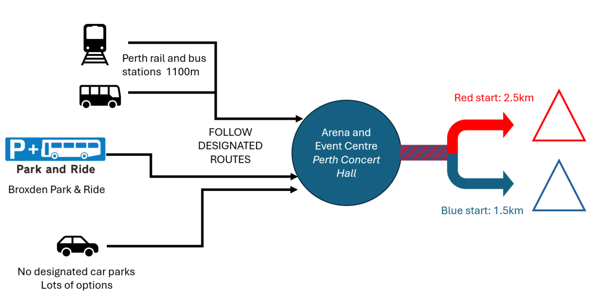
When planning your arrival, please read the details below explaining routes for access to the arena when planning your arrival.
There are several options available for travelling to Perth. We recommend using public transport where possible but recognise that many people will be travelling considerable distances to the JK. Travel options include:
Train: Perth is well served by trains from Glasgow, Stirling, Edinburgh and the north. Perth railway station is about 1100m (15 minutes) from the arena.
Buses: Local and long distance buses serve Perth. Bus station is close to the railway station, 10-15 mins walk from arena.
Park & Ride: this is located at Broxden, adjacent to the M90 and A9. Perth Park&Ride (Broxden) - Perth & Kinross Council Note that the Park & Ride buses will NOT use Mill Street on the day as we have closed that road for our arena and finish area. Passengers will alight from the Park & Ride buses outside the competition area.
Parking: Perth has numerous car parks and some on-street parking (see below).
There are car parking restrictions for JK competitors, so please read carefully if you are driving to the event:
- most car parking within the competition area is closed on the day but there are a large number of other car parks within easy walking distance of the arena. Details of car parking are here: Parking in Perth city centre - Perth & Kinross Council. Note maximum time restrictions (4 hours) that apply in some car parks.
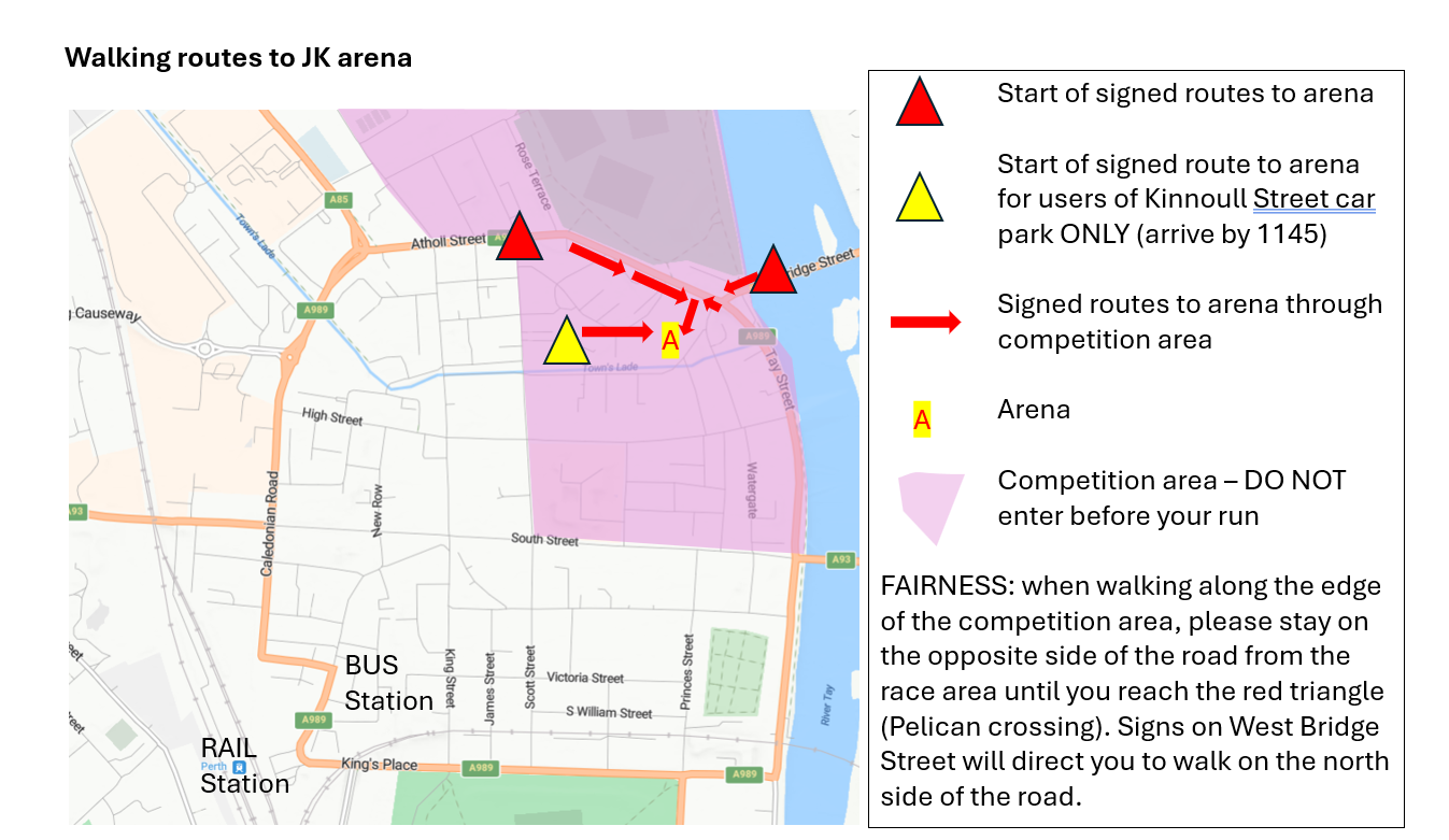
- the largest car park, Kinnoull Street multi-storey, is available ONLY for competitors arriving before 1145. All-day parking is available here. The car park itself lies within the competition area, and competitors MUST use the northern or eastern exits from the car park and follow signs and marshals’ instructions to reach the arena. Please DO NOT leave the marked route.
- If all JK competitors use Kinnoull Street car park, we will fill it and restrict access for local workers, shoppers and others. Please consider alternatives, and leave the closest parking for those who are less able to walk further.
- NOTE that parking in some car parks is only allowed for up to 4 hours.
- NOTE that the following car parks are within the competition area and MUST NOT be used by competitors: Mill Street East; West Mill Street; North Port; Watergate; Blackfriars Wynd; Rodney Pavilion; Riverside or Bells Sports Centre. Some of these are on roads that are closed for the competition.
- No on-street competitor parking is permitted within the embargo area shown below.
EMBARGO AREA: you may drive or cycle along roads that border the embargo area to reach parking locations. Walking and cycling routes to the arena MUST follow the routes shown below. Motor vehicles may use South Street bridge (A93) and pedestrians and cyclists may use North Bridge.
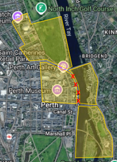
Once in Perth, access to the arena is ONLY by the routes indicated below. In particular, competitors MUST not walk along Tay Street between the A93 (South Street) and West Bridge Street. This is important to protect the integrity of the competition.
After racing, you may visit any part of the competition area, while watching out for runners still on their courses.
Important Information
- Most of the roads within the competition area will have very little traffic during the race, and any traffic will be at low speed. Traffic management is in place, by arrangement with Perth & Kinross Council, to redirect residents and other users away from the competition area. Competitors arriving in Perth will be subject to these restrictions and will see signs redirecting traffic on the day. This allows us to offer junior courses with no age restrictions.
- We have to maintain emergency vehicle access in the competition area at all times. Please be aware that this is a possibility. Marshals will instruct competitors in the event of this taking place.
- Bicycles and e-bikes are used within the competition area, although not in large numbers. Signs and marshals will warn users of these vehicles about the competition, but competitors should remain vigilant when crossing roads.
- Marshals will be present throughout the competition area. Competitors must follow marshals’ instructions.
- Full risk assessments have been undertaken for the JK and to meet the requirements of the Council, Police Scotland and other emergency services.
- Good Friday is a working day for many in Scotland, and the city centre will be busy with both normal Friday activities and visitors. We have delayed the first start time for the JK to leave a route through the city clear for a Good Friday church procession.
- Dogs are allowed in the arena, but not in the event centre.
- The event arena will impact on businesses in the area; marshals will ensure that access is maintained for the public, but orienteers are reminded that we are dependent on the goodwill of locals to run this event and are requested to support the cafes, craft shops and other businesses within the embargo area after racing.
Event Centre
- The Event Centre in Perth Concert Hall will be open to competitors from 10am. It contains enquiries, bib collection, SI card collection, car key drop, trophy return, toilets, merchandise collection and space to leave bags.
- Entry on the Day is available for 2 novice courses; registration for these courses is alongside Enquiries.
- Download and map drop/reclaim (by club, until the last start) are located inside the Event Centre adjacent to the finish. Competitors MUST follow tapes directly from the finish to download and map drop/reclaim.
- We need to control access to the Event Centre, to separate download from other event centre services. Please follow signs and marshals’ instructions for entry and exit.
- A coffee bar will be open serving snacks and water points are also available.
Arena
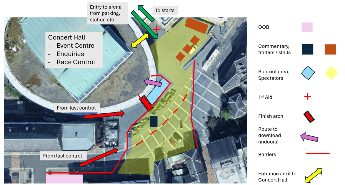
- Space is available within the event centre for bags to be left. Bags MUST not be left on the road in Mill Street in case we have to re-open this for emergency vehicle access at short notice. We do not recommend leaving bags outside in the arena for security reasons, and no bags or clothing should be deposited on the area of seating beside the commentary position.
- Apologies, but there is no space for club tents and no soft ground for placing club flags. Fencing with banners from our sponsors Altra, British Orienteering and Scottish Orienteering Association, and the finish arch, will provide a focal point for the arena.
- CompassPoint will be open for business in the plaza area, along with a Scottish Orienteering Association display.
- First Aid provided by ESG Medical is located in the plaza.
Starts
| Course | Distance | Notes | |
|---|---|---|---|
| Red | 1,2 (WRE courses), 3, 4, 5, 6 | 2.5km (35 min) | Model map provided for WRE competitors only. Plenty of space to warm-up. |
| Blue | 7, 8, 9, 10, 11, 12, 13, 14, 15, 16, 17, 18 | 1.5km (24 min) | Plenty of space to warm-up; please respect OOB signs. |
Times are for a steady walk, noting possible delays at light-controlled road crossings. The timings above include an extra 5 minutes for these crossings.
Routes to both starts leave the NE side of the arena. Signs (arrows) and coloured tapes will guide runners to the start. Marshals will be located at major road crossings and other critical points along these routes. Some signs along the route to the red start will have map extracts attached, showing the next segment of the route.
Competitors on the way to the starts MUST remain on the same side of the road as the tapes/signs and MUST follow marshals’ instructions for crossing roads. Failure to follow these instructions may result in disqualification.
Clothing may be left in bin bags at the starts. These bags will only be returned to the arena after the last start. Please keep this to a minimum, and no rucsacs please.
If you want water at the start, please bring your own. Recycling and rubbish bags will be provided at both starts, for plastic water bottles and other rubbish. Please ensure that all waste material is placed within the appropriate bag.
Toilets
There are many toilets in the Event Centre. A limited number will be available at both starts. Please allow time for queuing if you expect to need to use these facilities. Any competitor seen using bushes will be disqualified – our permission to hold the event is conditional on providing toilet facilities and on our competitors using these.
Course Information
| Course | Classes | Distance (km) | Climb (m) | Controls | Start | Map Scale | Map Flip? |
|---|---|---|---|---|---|---|---|
| 1 | M18E, M20E, M21E | 4.2 | 30 | 27 | Red | 1:4000 | Yes |
| 2 | W18E, W20E, W21E | 3.7 | 20 | 25 | Red | 1:4000 | Yes |
| 3 | M35, M40, MOpen | 3.5 | 15 | 25 | Red | 1:4000 | Yes |
| 4 | M45 | 3.5 | 15 | 26 | Red | 1:4000 | Yes |
| 5 | M14, M16 | 3.4 | 10 | 23 | Red | 1:4000 | Yes |
| 6 | M50 | 3.2 | 10 | 22 | Red | 1:3000 | Yes |
| 7 | M55 | 3.0 | 5 | 20 | Blue | 1:3000 | No |
| 8 | W35, WOpen | 3.1 | 5 | 21 | Blue | 1:4000 | No |
| 9 | W14, W16 | 3.0 | 5 | 23 | Blue | 1:4000 | No |
| 10 | M60 | 3.0 | 5 | 23 | Blue | 1:3000 | No |
| 11 | W40, W45 | 2.7 | 5 | 17 | Blue | 1:4000 | No |
| 12 | M65, W50 | 2.7 | 5 | 18 | Blue | 1:3000 | No |
| 13 | M70 | 2.6 | 5 | 17 | Blue | 1:3000 | No |
| 14 | W55, W60 | 2.6 | 5 | 17 | Blue | 1:3000 | No |
| 15 | M75, W65, W70 | 2.2 | 5 | 14 | Blue | 1:3000 | No |
| 16 | M80, M85, M90, M95, W75, W80, W85, W90, W95 | 2.0 | 5 | 15 | Blue | 1:3000 | No |
| 17 | M12, W12, Novice Adult | 2.1 | 5 | 22 | Blue | 1:4000 | No |
| 18 | M10, W10, Novice Junior | 1.7 | 5 | 18 | Blue | 1:4000 | No |
The full length of the elite control descriptions is 200mm for Course 1 and 190mm for Course 2.
All courses other than courses 15 and 16 have a spectator control adjacent to the arena.
Terrain
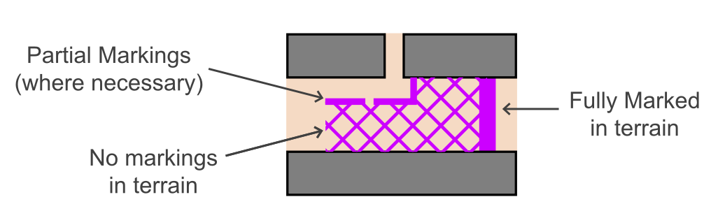
Perth is a typical urban area with a largely pedestrianised centre. There is a lot of street furniture, eg bollards and signs, most of which is not mapped; statues and similar are mapped with the “cairn” symbol and large bike racks with “x” (special symbol). Roads are shown with pavements & kerbs. In the urban area, olive green is used for private areas not to be accessed, mostly being fenced or chained; in the parkland, olive green is used for uncrossable flower beds. Where uncrossable features may be ambiguous, tape is used to denote the boundary of these features. This will not be done for all uncrossable features, and the absence or ending of tapes does not imply the end of an uncrossable feature.
Model Area
A model area map is available close to the Red start for WRE competitors only. Other competitors may warm-up in this area. The model area includes controls to show the set- up of controls in the competition, and an area of taped-off OOB to demonstrate how some particularly sensitive OOB areas are taped. All OOB areas are clearly shown on the map using standard ISSprOM symbols.
Quarantine
There is no quarantine for the WRE race. All competitors are reminded of the spirit of fairness and not to discuss any aspect of the course or terrain with those yet to run.
Clothing and Footwear
Shorts and running vests are permitted. Spikes and dob spikes are not allowed. In the event of wet weather, some pavements, steps and grass areas will be slippery.
Safety
Marshals will be present throughout the area to ensure the safety of competitors, residents and the public.
Competitors must exercise care and be respectful of other users of the area. Please look out for pedestrians and other competitors when running around tight bends or exiting alleyways. Competitors may encounter small amounts of traffic in some parts of the area.
Competitors on courses using the Red start will use pavements alongside roads that remain open and which are marked Out Of Bounds on the map (with cross-hatching). Marshals will encourage the public away from these pavements but cannot force people to use alternatives. Competitors should be aware of, and permit overtaking by, faster runners behind them on these pavements. When overtaking, do not step onto the road.
Commentary
Commentary will be provided by Holly Stodgell and Katherine Bett, with facilities provided by Amplified Sound. In the event of dry weather, for the final hour of the WRE races there will be ‘leaders’ chairs’ adjacent to the commentary van. Race leaders may be interviewed.
Prizegiving
Start times have been allocated to allow the Women’s WRE race to conclude at about 1530, and the Men’s at about 1545. The WRE Flower Ceremony will take place as soon as the final WRE competitors have downloaded.
Immediately after the WRE Flower Ceremony, British Orienteering will present a range of awards for 2025. This will be followed by the JK Sprint prizegiving. Please stay to support the athletes and volunteers who will be recognised in these ceremonies.
Maps
Survey and cartography to ISSprOM 2019-2 for JK26 by Graham Gristwood (FVO).
Scales are 1:4000 or enlarged to 1:3000 as appropriate for some courses, with a 2.5m contour interval. The course table shows which courses have a map flip.
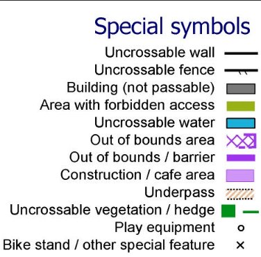
Please make yourself familiar with the forbidden access symbols and also special symbols used on the map.
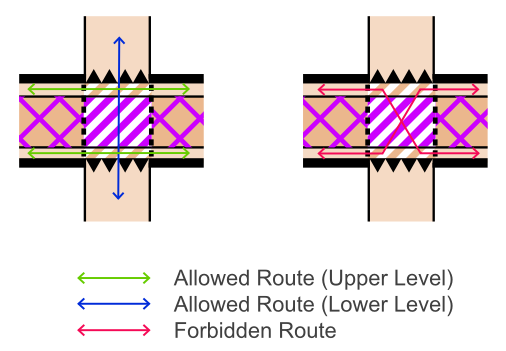
Artificial barriers are shown on all maps, as below. These are marked on the ground by barriers and/or tapes and may be marshalled. The barriers are permeable to allow the public to pass through, but competitors must not cross these.
The mapping of underpasses is as shown below. It is not permitted to cross the upper level road above the underpass.
Maps from previous events can be found on Routegadget:
Acknowledgements
Thanks to Perth Theatre and Concert Hall for providing the event centre; to Perth and Kinross Council for facilitating access and logistics; to Alba Traffic Management and Tayside Contracts for traffic management; to Perth churches for their cooperation in scheduling on an important day in their calendar; to Marks and Spencer for re-locating their click and collect service during the event; and, to all residents and businesses within the race area for their support, encouragement and understanding.
Officials
| Planners | Fiona Eades (INT), Joe Sunley (MA) |
|---|---|
| Organisers | Trevor Hoey (FVO), Cathy Tilbrook (FVO) |
| Controller | Keith Tonkin (BL) |
| IOF Advisor | Ted Finch (FVO) |
| Helpers | AROS, AYROC, ESOC, EUOC, GRAMP, KFO, TAY and individual volunteers |
| Jury | Graeme Ackland, Simon Errington, Alan Rosen |